Data distribution service - メーカー・企業と製品の一覧

Data distribution serviceの製品一覧

1~6 件を表示 / 全 6 件

表示件数

PPK, leave the post-processing analysis to us! Genova's post-processing data distribution service.

Distributing reference station data (RINEX data) used for PPK and post-processing analysis in GNSS positioning! Utilized in MMS, aerial surveying, and drone surveying.

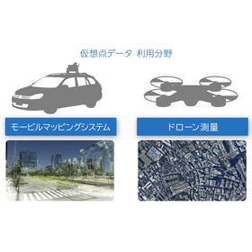
Satellite positioning can be performed independently without using network communication, and by analyzing the observed data along with reference station data (RINEX data) using post-processing analysis software, high-precision location information can be obtained. Regarding reference station data, there is no need for the physical installation of reference stations; it can be obtained through a method that virtually generates data at specified coordinates (virtual points) or by downloading it from designated electronic reference points provided by the Geospatial Information Authority of Japan. ■ A video explaining "virtual point data" in an easy-to-understand manner is available here: https://www.jenoba.jp/movie3.html 【Main Use Cases】 - Public surveying, land and property surveys - Surveys (measurements) and inspections using drones and UAVs - Aerial surveying - Mobile Mapping Systems (MMS) - 3D map creation 【Features of the Distribution Service】 - High-precision positioning is possible without network connection on-site - No need for the installation of reference station facilities - Data from the past six months can be obtained at one-second intervals - "Electronic reference station data" and "virtual point" data are available; by specifying nearby reference station locations for virtual point data, even higher precision positioning can be expected.

  • Surveying Office
  • Other measuring instruments
  • Other civil engineering works

ブックマークに追加いたしました

ブックマーク一覧

ブックマークを削除いたしました

ブックマーク一覧

これ以上ブックマークできません

会員登録すると、ブックマークできる件数が増えて、ラベルをつけて整理することもできます

無料会員登録

"GNSS Positioning Location Information Services" *Case Study Collection Giveaway

Manage work vehicles with high-precision positioning! No need to install base stations. Increased productivity and cost reduction!

Our company provides a service that receives and analyzes real-time data from electronic reference points released by the Geospatial Information Authority of Japan, delivering high-precision positioning correction data. With our unique technology, we respond to demands for improved accuracy and cost reduction, offering network-based RTK positioning correction data suitable for our customers' businesses. Using our services, various activities such as general surveying, land and house surveyor work, and civil engineering construction are being conducted, and we have compiled some case studies. This time, we have added examples of utilization in the "UAV/Drone" field for unmanned operations. 【Examples of Utilization for Unmanned Operations】 ■ Application to Firefighting Robot Systems In fires where firefighters cannot approach, the robot makes decisions and acts on its own. *For more details on the case studies, please download the materials. Feel free to contact us with any inquiries.

  • Other earthworks, foundation works, and exterior floors
  • Other measuring instruments
  • Surveying

ブックマークに追加いたしました

ブックマーク一覧

ブックマークを削除いたしました

ブックマーク一覧

これ以上ブックマークできません

会員登録すると、ブックマークできる件数が増えて、ラベルをつけて整理することもできます

無料会員登録

Weather data distribution service

Various weather and disaster prevention information available online!

The "Weather Data Distribution Service" is a service that provides detailed weather information for municipalities, including forecasts for weather, ultraviolet rays, pollen dispersion, and cherry blossom blooming, as well as disaster prevention information such as earthquakes and typhoon paths or weather warnings issued urgently by the Meteorological Agency. This service includes data distribution and download options. Please utilize this practical information related to corporate operations such as disaster management and data science (product management and demand forecasting). 【Features】 ■ Affordable provision of local weather and regional disaster prevention information ■ Easy-to-handle data that requires no hassle, effective in reducing development costs ■ No delay from application to data distribution *For more details, please download the PDF or feel free to contact us.

  • Weather Survey
  • Other Software

ブックマークに追加いたしました

ブックマーク一覧

ブックマークを削除いたしました

ブックマーク一覧

これ以上ブックマークできません

会員登録すると、ブックマークできる件数が増えて、ラベルをつけて整理することもできます

無料会員登録

Content data distribution service "Super POP CDS"

[Recruiting Agents] Renewable with Electronic POP! Proposal for a cloud-based content data distribution service.

"Super POP CDS" is a service that delivers content data for electronic POP broadcasting in a cloud format. Content data uploaded to the server can be downloaded to devices such as smartphones. By using a compatible card reader from the device, the relevant data can be written to an SD card or USB memory and played back on electronic POP. 【Features】 ■ Delivered in cloud format ■ Content data can be downloaded to devices ■ Playable on electronic POP *For more details, please refer to the PDF document or feel free to contact us.

  • media

ブックマークに追加いたしました

ブックマーク一覧

ブックマークを削除いたしました

ブックマーク一覧

これ以上ブックマークできません

会員登録すると、ブックマークできる件数が増えて、ラベルをつけて整理することもできます

無料会員登録

GNSS High-Precision Data Distribution Service

Contributing to significant improvements in work efficiency and cost reduction in various fields that require high-precision positioning through the use of real-time data from electronic reference points!

Our company receives real-time data from electronic reference points provided by the Geospatial Information Authority of Japan at the Genova Center, conducting analyses 24 hours a day, 365 days a year, and offering high-precision positioning correction data delivery services to our customers. Utilizing our unique technology (JENOBA method) that leverages real-time data from electronic reference points, we respond to demands for "improved accuracy" and "cost reduction," while aiming to provide network-based RTK positioning correction data that is optimal for our customers' businesses. 【Features】 ■ High-quality data delivery considering crustal deformation ■ Alignment with results from the nearest electronic reference point ■ Delivery suitable for surveying operations with "technical collaboration with GNSS manufacturers" ■ Reduced personnel and equipment, leading to significant cost savings ■ Reduced workload and increased efficiency through the use of virtual point method static data *For more details, please refer to our catalog or feel free to contact us.

  • Other measuring instruments
  • Surveying

ブックマークに追加いたしました

ブックマーク一覧

ブックマークを削除いたしました

ブックマーク一覧

これ以上ブックマークできません

会員登録すると、ブックマークできる件数が増えて、ラベルをつけて整理することもできます

無料会員登録

GPS High-Precision Data Distribution Service

Contributing to significant improvements in work efficiency and cost reduction in various fields that require high-precision positioning through the use of real-time data from electronic reference points!

Our company receives real-time data from electronic reference points provided by the Geospatial Information Authority of Japan at the Genova Center, conducting analyses 24 hours a day, 365 days a year, and offering high-precision positioning correction data delivery services to our customers. Using our unique technology (JENOBA method) that utilizes real-time data from electronic reference points, we respond to demands for "improved accuracy" and "cost reduction," while aiming to provide optimal network-based RTK positioning correction data for our customers' businesses. 【Features】 ■ High-quality data delivery considering crustal deformation ■ Alignment with the nearest electronic reference point results ■ Delivery suitable for surveying operations with "technical collaboration with GNSS manufacturers" ■ Reduced personnel and equipment, significantly lowering costs ■ Reduced workload and increased efficiency through the use of virtual point method static data *For more details, please refer to the catalog or feel free to contact us.

  • Other measuring instruments
  • Surveying

ブックマークに追加いたしました

ブックマーク一覧

ブックマークを削除いたしました

ブックマーク一覧

これ以上ブックマークできません

会員登録すると、ブックマークできる件数が増えて、ラベルをつけて整理することもできます

無料会員登録